- VitalCore Newsletter
- Posts
- Hurricane Season Decoded
Hurricane Season Decoded
The Science and Surprises Behind the Storms
Vital Corps
November 02, 2025

In just 24 hours, a hurricane can erase decades of construction, toss cars like toys, and leave entire neighborhoods under water. These sprawling storms—known as hurricanes, typhoons, or tropical cyclones depending on where they roam—pack more damaging power than almost any other force in nature. Some last only days; the biggest linger for a week or more, unleashing winds that can snap steel, rainfalls measured in feet, and storm surges that swallow coastlines whole. When you glance at a map and see a spiraling dot, a cone of possibility, and a quick “Category 3” label, it’s easy to forget that behind those symbols lies a roaring engine that runs on ocean heat and can transform a placid sea into a disaster zone. To make sense of the chaos, it helps to dig into where these storms get their fury and why the numbers and symbols we use to track them only tell part of the story.
How it Forms
A hurricane starts as a loose collection of thunderstorms over warm ocean waters. The key ingredient is the ocean: when the surface temperature is around 80°F (about 26.5°C) or higher through a deep layer, evaporation loads the air with invisible water vapor. As this water vapor rises and condenses into cloud droplets, it releases heat into the surrounding air. This released heat isn’t just a byproduct, it’s the storm’s energy source. The heat warms the air, causing it to rise even faster, drawing in more moist air from below and helping the storm grow. If the surrounding atmosphere is humid and a bit unstable, these updrafts keep building rather than being choked off by dry air. Close to the equator, the Coriolis effect is too weak to encourage rotation, but move a few degrees farther from the equator and the planet's spin imparts a slight twist, helping the showers organize into a broader, spinning system. Wind shear (the change of wind speed or direction with height) acts as a gatekeeper. Too much shear will topple and disrupt the storm’s structure; too little, and the updrafts can stack neatly on top of each other, turning the system into a more efficient heat engine.
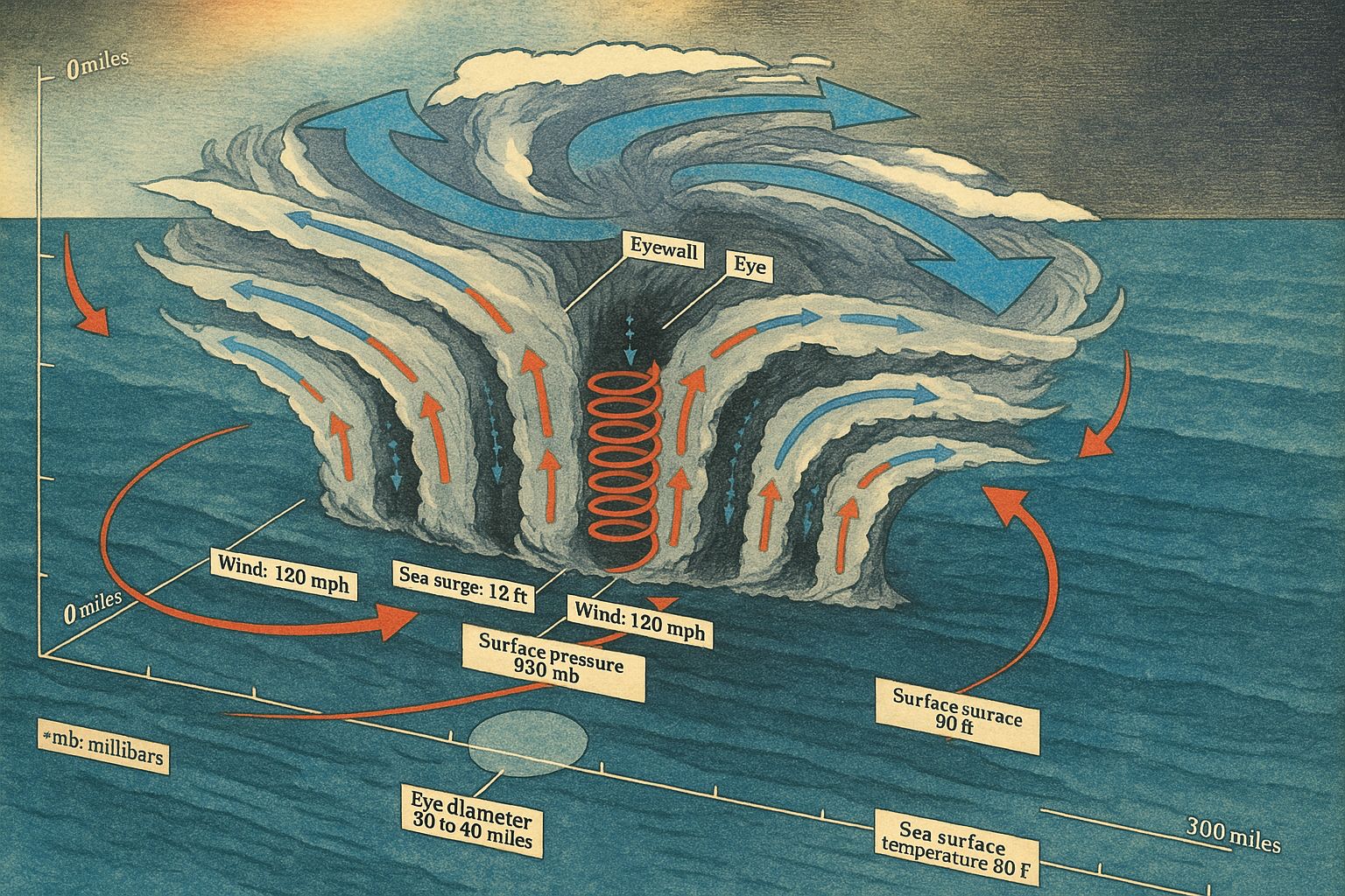
When a storm’s winds begin to circle and close at the surface, but are still not very strong, experts call it a tropical depression. This name does not mean someone is sad; it just shows that the storm is getting more organized. If the storm gets stronger and its steady winds increase, it becomes a tropical storm and is given a name. In this stage, the center of the storm is forming, and several things happen: air at the surface spirals inward, the pressure in the center falls, air moves in faster, and more air rises and turns into clouds. As this happens, heat is released, which makes the pressure drop even more. When the steady winds reach 74 miles per hour, the storm is called a hurricane. This new name means the structure has changed: now, the middle is a calm area called the “eye,” surrounded by the dangerous eyewall, where the strongest winds and biggest thunderstorms are found.
Inside the eye, air is subsiding and the sky can even be blue, a deceptive calm framed by walls of cloud. In the eyewall the vertical motions are so strong that precipitation wraps into bands and wind speeds reach their peak. From the core, rainbands spiral outward like the grooves on a record, delivering bursts of heavy rain and gusty winds far from the center. Near the ocean surface, inflow converges toward low pressure; high above, air that rose in the eyewall fans outward as outflow. This high-level exhaust is essential: it allows more air to ascend below, keeping the heat engine running. The whole structure is a heat pump ferrying energy from the sea into the sky, turning it into wind.
However, not every storm that moves over warm water becomes a hurricane. Sometimes dry air gets pulled in and stops the storm from growing. Strong wind shear can break the storm apart. Forecasters look at the amount of heat in the whole ocean, not just the surface, because if the warmth is only at the top, it can mix away. Deep layers of warm water provide steady fuel to power the hurricane. If the storm moves over land, it loses its energy source. But when the conditions are just right - deep warm water, lots of moisture in the air, gentle wind shear, and a small system with some rotation - the storm can quickly get much stronger.
Categories
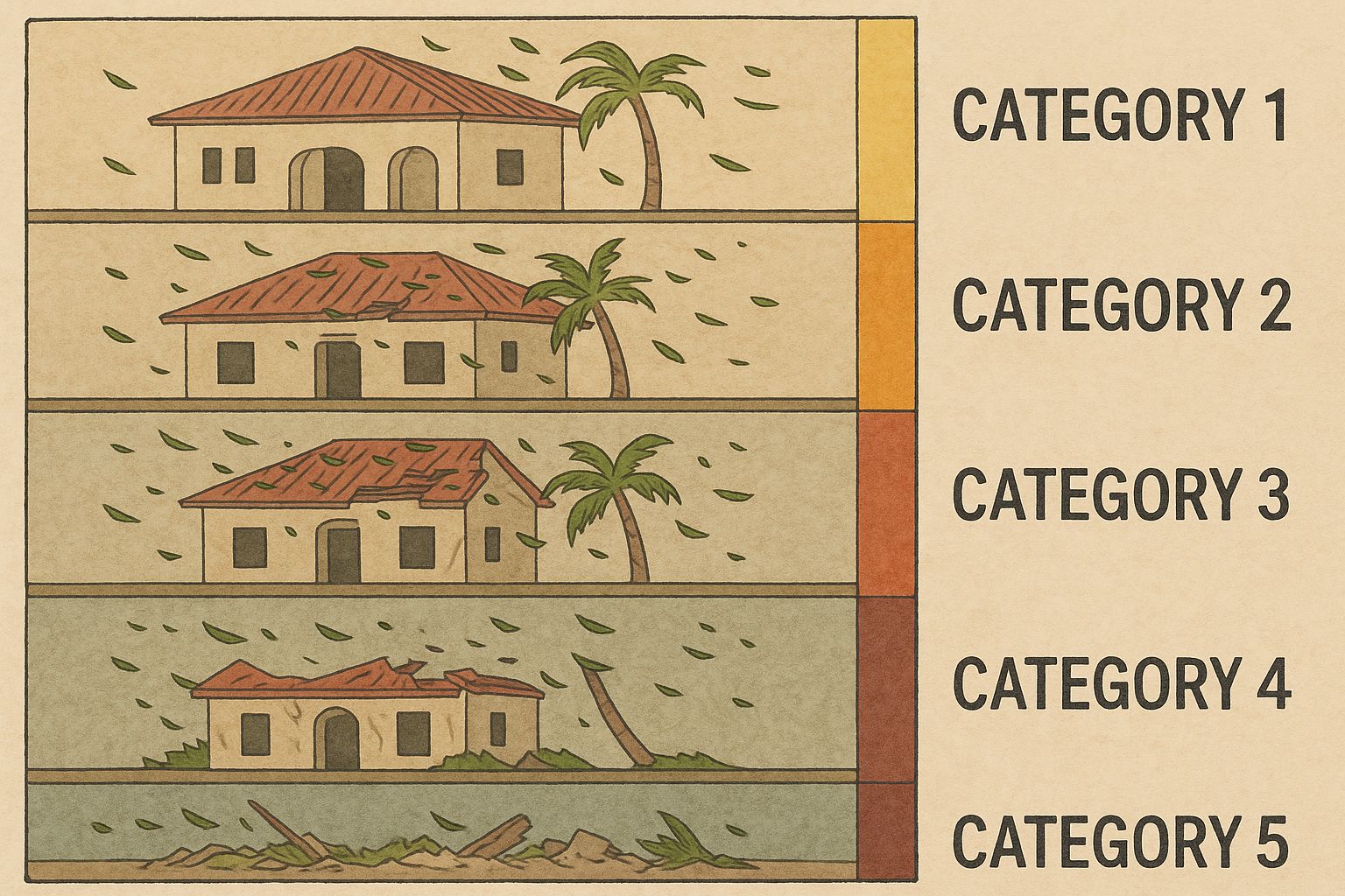
The category number commonly shown on maps comes from the Saffir–Simpson Hurricane Wind Scale. It is a wind-only classification that uses the maximum sustained wind averaged over one minute at about ten meters above the surface. Category 1 covers winds from 74 to 95 miles per hour, enough to peel shingles, topple shallow-rooted trees, and trigger scattered power outages. Category 2 spans 96 to 110 miles per hour, with more extensive roof and siding damage and larger swaths of downed trees that lengthen outages. Category 3, from 111 to 129 miles per hour, is considered “major,” with some structural failures and the possibility that water and power will be unavailable for days to weeks.
At Category 4, 130 to 156 miles per hour, damage becomes severe: many roofs and exterior walls fail, and infrastructure can be disrupted for a long time. Category 5 begins at 157 miles per hour and higher, where catastrophic damage is typical and a high percentage of framed homes can be destroyed, leaving areas potentially uninhabitable for weeks or months. The scale is useful because wind damage correlates reasonably with these bins, but it is incomplete by design. It says nothing about the storm’s size, the volume of rain it will drop, the height of the storm surge, or how fast it is moving—factors that often dominate risk.
Storm Surge
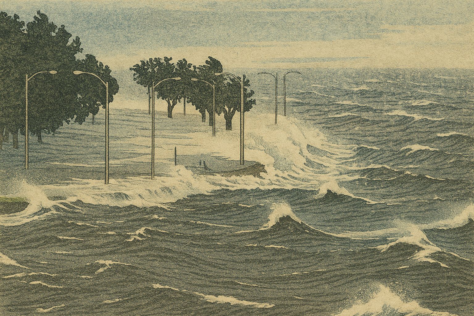
Storm surge is especially important to understand. A storm’s strong winds push ocean water onto the land, and the drop in air pressure lets the sea surface rise even higher. How high the storm surge gets depends on things like the shape of the sea floor, the coastline, the size of the storm, and the timing with the tides. Sometimes, a big, slow-moving Category 2 hurricane can bring a higher surge in a bay than a small, fast-moving Category 4 that passes quickly. Flooding from heavy rain depends in a similar way on the storm’s speed and size. If a storm moves slowly over ground that is already wet, even a low-category hurricane can cause very bad flooding. This is why weather experts give separate warnings for storm surge and rainfall, and why you should not rely only on the hurricane’s category to decide what to do.
Asymmetry
There is another detail called asymmetry. In the Northern Hemisphere, the right-front part of a hurricane’s path (the direction it is moving) usually has the strongest winds, because the storm’s forward speed adds to the circular wind there. This part also has a higher chance for tornadoes in the outer rainbands. On the left side, winds can be much weaker. Once the storm moves inland, dangers change. The strong wind weakens first, but heavy rain can still cause flash floods, river floods, or landslides for days as the storm’s rain moves along its path and into the hills or mountains.
Forecasting
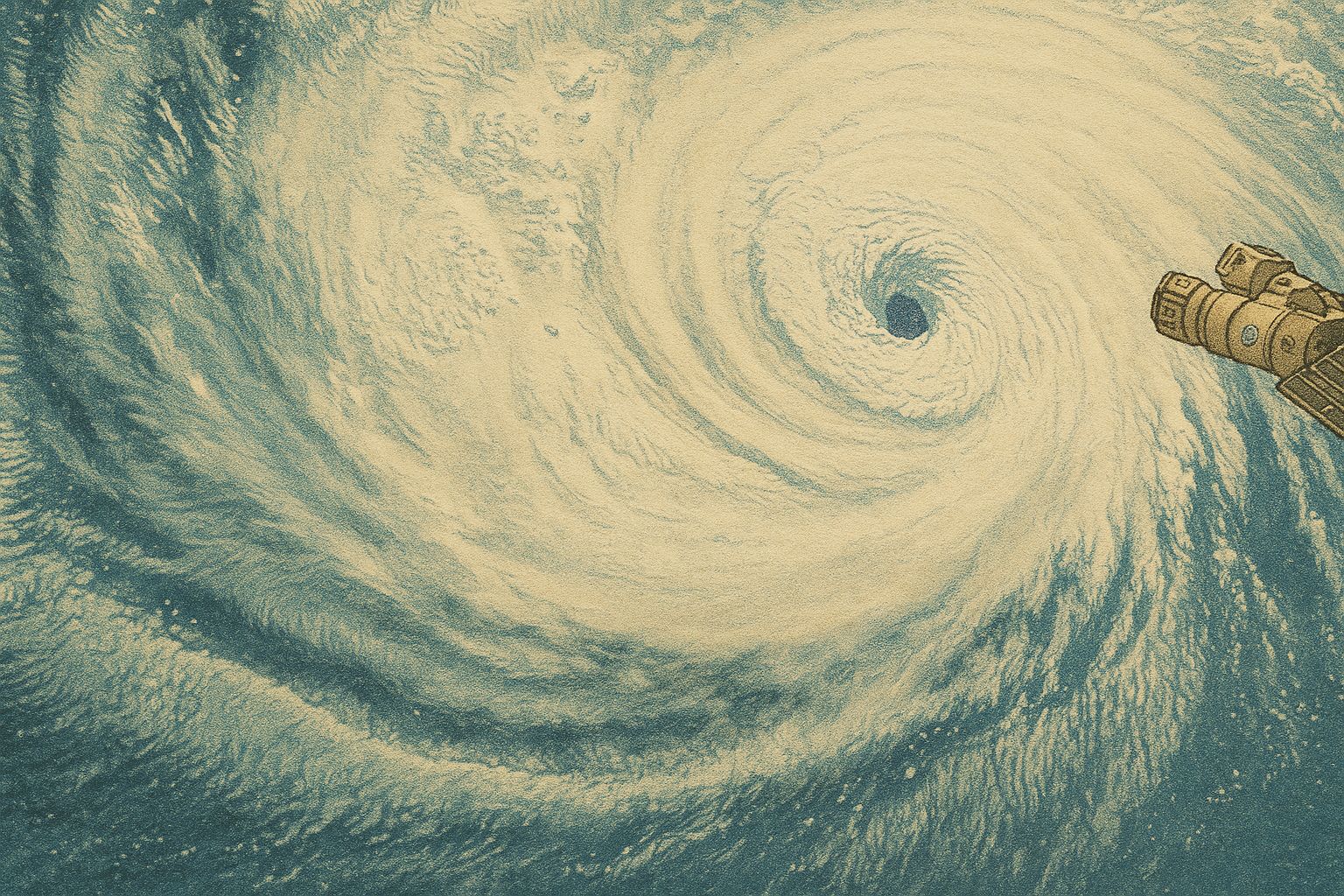
Forecasting has improved dramatically in recent decades. Track predictions are more accurate and extend farther into the future, giving people more time to prepare. Intensity forecasts, especially rapid intensification, remain tougher because they depend on small-scale processes in the core that are hard to measure and model. New satellites, ocean floats, hurricane hunter aircraft, and high-resolution models are steadily closing that gap. For the public-facing picture, the cone of uncertainty shows where the center is likely to go, but hazards extend well beyond it. Rain and surge do not respect the edge of a cone.
More than meets the eye
If there is a single takeaway, it is that a hurricane is a heat engine shaped by its environment, and the category number captures only the top wind near the core. Warm water and moisture power the machine; wind shear and land interaction regulate it; size and speed influence how and where hazards unfold. Pay attention to the whole suite of forecasts—wind, rain, surge, and timing—not just the label next to the storm’s name. With that context, the moving dot and the changing number on a map tell a fuller story about what to expect and why the ocean and atmosphere sometimes conspire to produce a calm eye surrounded by so much force.